For centuries, ancient maps depicting Antarctica without ice have fascinated researchers, historians, and the general public. These maps, some created long before modern discovery methods, raise significant questions about ancient civilizations and their potential knowledge of Earth’s geography. Understanding why these maps exist and what they reveal requires examining history, cartographic evidence, and scientific perspectives. See here why ancient Antarctica maps show no ice. The mystery of some maps showing mountains and key details are hard to explain.
The Mystery of Ancient Antarctica Maps
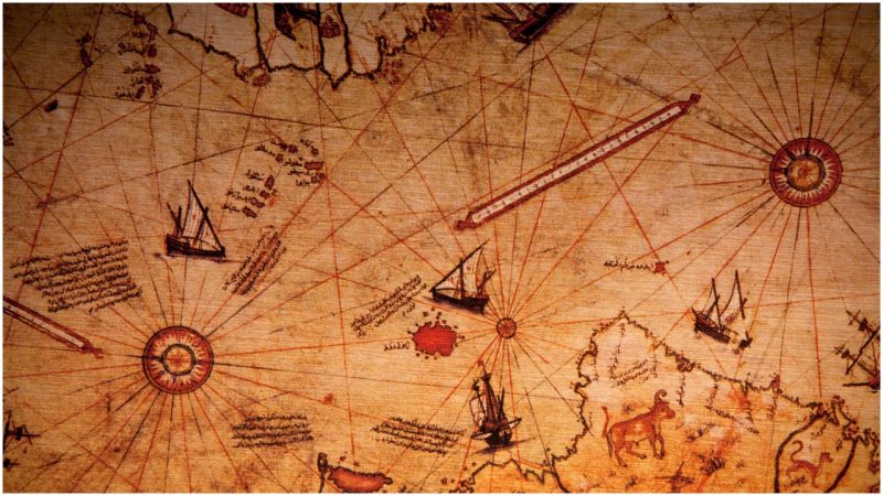
Antarctica’s official discovery occurred in 1820 when explorers first sighted its icy shores. However, maps predating this period challenge this timeline. The most famous example is the Piri Reis map, created in 1513. This map, drawn by an Ottoman admiral, includes a remarkably accurate depiction of Antarctica’s coastline—without ice. Such precise cartography is puzzling given the limited exploration and technological capabilities of the time.
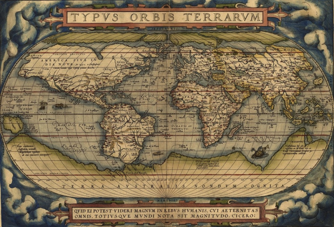
Other maps, including the Orontius Finaeus map of 1531, show similar features. These maps suggest detailed knowledge of Antarctica’s topography, which modern geologists only confirmed through radar imaging beneath the ice. These findings fuel debates about the existence of advanced ancient civilizations or lost knowledge.

Geological Evidence and Ice-Free Periods
To understand why these maps show Antarctica without ice, examining geological history is crucial. Scientists know Antarctica was not always covered by ice. Millions of years ago, the continent had a temperate climate, with forests and thriving ecosystems. Evidence suggests Antarctica became covered in ice approximately 34 million years ago due to climatic changes.
However, recent studies indicate there may have been periods of partial deglaciation during more recent epochs. For example, during the last interglacial period around 120,000 years ago, global temperatures rose, causing significant ice melt. While Antarctica likely remained mostly ice-covered, some coastal regions may have been exposed. These exposed areas could align with ancient map depictions, suggesting that maps reflect observations made during warmer periods.
Advanced Ancient Civilizations or Lost Knowledge?
The idea that ancient civilizations had advanced knowledge of geography continues to intrigue researchers. Some theories propose that ancient seafarers or explorers mapped the Earth with precision. These civilizations might have developed techniques for surveying and recording data that are now lost to history.
One hypothesis suggests that ancient mariners traveled to Antarctica during an ice-free period, documenting its geography. These records could have been passed down through generations, influencing later mapmakers. Alternatively, some believe knowledge may have originated from a lost civilization, such as Atlantis, described in legends.
Critics argue that these theories lack concrete evidence. They suggest that ancient maps showing Antarctica without ice are likely speculative or based on misinterpretations of other regions. However, the accuracy of certain features, such as mountain ranges and coastal outlines, remains difficult to dismiss entirely.
Influence of Medieval and Renaissance Cartography
Medieval and Renaissance cartographers often relied on older sources for their maps. These sources included ancient Greek and Roman texts, sailor’s accounts, and possibly older maps now lost. The Piri Reis map explicitly cites earlier documents as references, including maps from the Library of Alexandria.
Renaissance scholars, fascinated by rediscovered classical knowledge, sought to compile all available geographic information. In doing so, they may have incorporated data from ancient maps that included depictions of Antarctica. The blending of factual and speculative information often resulted in maps that both amazed and confounded later generations.
Modern Science and Subglacial Discoveries
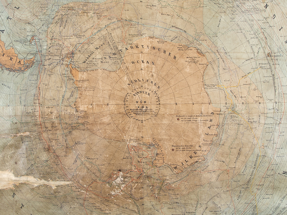
Modern science offers insights into how ancient maps could show ice-free Antarctica. Advances in radar and satellite imaging allow researchers to study the continent’s subglacial features. These studies reveal striking similarities between ancient maps and the actual topography beneath Antarctica’s ice.
For example, the coastline depicted on the Piri Reis map closely matches modern reconstructions of Antarctica’s subglacial landforms. This raises the question: how could ancient cartographers have known these details without advanced technology? Some researchers speculate that ancient civilizations may have had observational techniques or inherited knowledge now lost.
Another possibility involves the gradual accumulation of knowledge through exploration and trade. If ancient mariners visited Antarctica’s ice-free regions, their observations might have been recorded and shared widely. Over time, these observations could have influenced medieval cartographers, creating the maps we find so mysterious today.
Climate Change and Historical Perspectives
Understanding ancient maps also requires considering the context of historical climate change. Earth’s climate has undergone numerous fluctuations over millennia. Periods of warming, like the Medieval Warm Period, impacted global ice coverage and sea levels. Although these changes were less dramatic than today’s anthropogenic warming, they may have exposed parts of Antarctica temporarily.
If ancient mariners traveled during a warmer epoch, their observations could have been accurate for that time. Over centuries, as ice reclaimed Antarctica, these maps became historical anomalies. This perspective emphasizes the dynamic nature of Earth’s climate and its influence on geography.
The Role of Myths and Misinterpretations
Myths and legends often intertwine with historical records, complicating efforts to discern fact from fiction. The idea of a southern continent, known as Terra Australis, existed long before Antarctica’s discovery. Ancient philosophers, including Aristotle and Ptolemy, theorized about a vast landmass balancing the northern continents.
Early cartographers included speculative depictions of Terra Australis on maps, blending geographic knowledge with imagination. Some researchers argue that maps showing ice-free Antarctica may reflect this tradition of speculative mapping. Features interpreted as Antarctica’s coastline could represent other regions or purely hypothetical geography.
However, the uncanny accuracy of some maps challenges this view. The detailed alignment of certain features with modern data suggests that at least part of these maps was based on genuine observations.
Implications for Historical and Scientific Research
The mystery of ancient Antarctica maps has significant implications for historical and scientific research. First, it challenges conventional timelines of exploration and cartographic development. If ancient civilizations had detailed knowledge of Antarctica, this suggests capabilities far beyond what historians currently acknowledge.
Second, it underscores the importance of interdisciplinary research. Solving the puzzle of these maps requires expertise in history, archaeology, geology, and climatology. By combining these fields, researchers can better understand how ancient maps came to exist and what they reveal about our past.
Finally, these maps remind us of the value of preserving knowledge. The loss of ancient records, such as those in the Library of Alexandria, highlights how fragile human understanding can be. Modern efforts to digitize and preserve information aim to prevent similar losses in the future.
Continuing Exploration and the Search for Answers
Despite centuries of study, the mystery of ancient Antarctica maps remains unresolved. Ongoing exploration and technological advancements may provide new insights. For example, improved radar imaging could reveal additional subglacial features matching ancient map depictions. Similarly, discoveries of ancient artifacts or records might offer direct evidence of early exploration.
Public interest in these maps continues to grow, fueled by documentaries, books, and online discussions. This interest reflects a broader fascination with humanity’s past and the potential for lost knowledge. By studying these maps, we not only seek answers to specific questions but also explore the boundaries of human achievement.
Conclusion
Ancient maps showing Antarctica without ice represent one of history’s most intriguing mysteries. They challenge our understanding of geography, history, and the capabilities of ancient civilizations. While many questions remain unanswered, these maps inspire ongoing research and curiosity. By examining their origins, context, and implications, we gain valuable insights into humanity’s enduring quest for knowledge. See here why ancient Antarctica maps show no ice. The mystery of some maps showing mountains and key details are hard to explain. Looking for more information on Antarctica? The Antarctica blog here on Arctic Ave has many topics on the mysteries place. Take a look.